


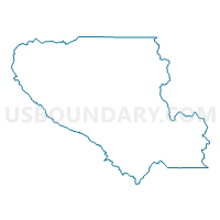
Voting District 10360, Santa Clara County, California
About
Outline

Summary
| Unique Area Identifier | 543574 |
| Name | Voting District 10360 |
| County | Santa Clara County |
| State | California |
| Area (square miles) | 0.06 |
| Land Area (square miles) | 0.06 |
| Water Area (square miles) | 0.00 |
| % of Land Area | 100.00 |
| % of Water Area | 0.00 |
| Latitude of the Internal Point | 37.15458790 |
| Longtitude of the Internal Point | -121.99656890 |
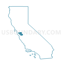
Maps

Graphs
Select a template below for downloading or customizing gragh for Voting District 10360, Santa Clara County, California


Neighbors
Neighoring Voting District (by Name) Neighboring Voting District on the Map
- Voting District 10390, Santa Clara County, CA
- Voting District 51395, Santa Cruz County, CA
- Voting District 51405, Santa Cruz County, CA
Top 10 Neighboring County Subdivision (by Population) Neighboring County Subdivision on the Map
- San Lorenzo Valley CCD, Santa Cruz County, CA (23,195)
- Lexington Hills CCD, Santa Clara County, CA (4,009)
Top 10 Neighboring Place (by Population) Neighboring Place on the Map
Top 10 Neighboring Elementary School District (by Population) Neighboring Elementary School District on the Map
- Los Gatos Union Elementary School District, CA (27,174)
- Lakeside Joint Elementary School District, CA (2,632)